
16 May Three Dams and a Changing Landscape
In 1933, the President Franklin Delano Roosevelt was leading a country deeply mired in the effects of the Great Depression. Particularly hard hit with poverty and suffering was the Tennessee River Valley, which included the counties along the East Tennessee Crossing Byway. In a bold step by Congress, the Tennessee Valley Authority (TVA) was created as part of the “New Deal” to improve the lives of the people across the region by reducing flooding, bringing electricity to rural communities, and to create jobs. One of the biggest impacts of the TVA was the building of hydroelectric dams across the Valley and the changed landscapes in communities and counties that were inundated by waters when the dams gates were closed.
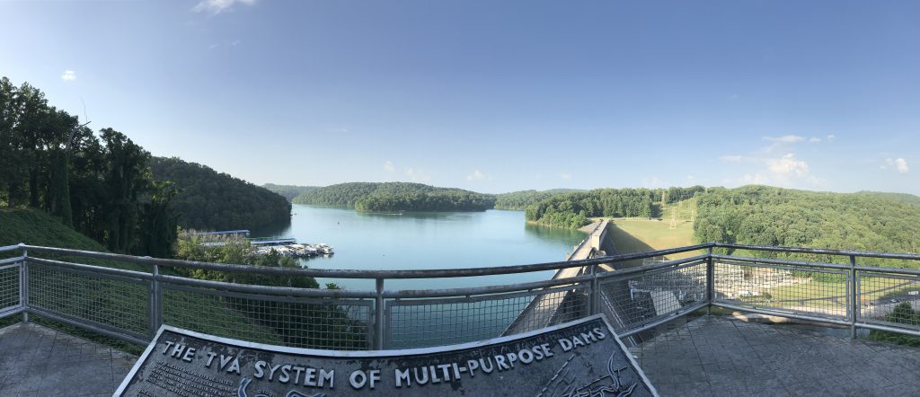
On your journey along the Byway, you will cross three TVA lakes and have an opportunity to take a side trip to see these engineering monuments that “tamed” a river system.
Norris Lake: The first TVA Dam
Work commenced on Norris Dam in 1933 at the Cove Creek site on the Clinch River. Workers came from the dust bowls of Oklahoma and the “stews” of New York to earn the living wages that this project work offered. When the gates closed in 1936, 2,841 families were relocated and 152,000 acres of land were purchased. Today, this recreational lake has almost 34,000 acres of water and 800 miles of shoreline. It is a popular recreational lake for anglers, boaters, and vacation homes. Norris Lake is the largest tributary lake in the Tennessee Valley.
The electric generating capacity is 126 megawatts of power, which was important to the building of the Secret City and the Manhattan Project during WWII.
Cherokee Lake: A Lost Community
The building of Cherokee Dam began in 1940 to help increase electric capacity for the war effort. The gates closed on December 5, 1941, two days before the attack on Pearl Harbor.
While the dam is located in Rutledge, the community most impacted was the historic community of Bean Station. At one time, this community served as a crossroads for travelers heading east- west (11W) and north-south (25E Byway.) of the Bean Station residents prior to the building’s dam, 87% of those families were forced to relocate. Historic sites such as the original frontier outpost of Bean Station, the Bean Station Tavern, the historic golf course at Tate Springs Resort, and the Civil War site for the Battle of Bean Station were all lost to the waters of Cherokee Lake.
Cherokee Dam’s generating capacity is 122 megawatts. TVA has invested in technology to improve fishing in the tailwaters, making both the lake and the tailwaters an angling destination. Other popular activities are boating and primitive camping on the lake islands.
Douglas Dam. Photo: Maggie Lynch
Douglas Dam- Agriculture to Aircraft
As a traveler crosses the headwaters of Douglas Lake, it is difficult not to notice the footprint of the rivers and railroads that reshaped this American frontier. From the footpaths and riverways of pioneers and Native Americans to modern travel such as railroads and automobiles, the Byway represents the storied migration of people from pre-American Revolution to modern day travel.
Similar to Cherokee Dam, Douglas Dam was built for the WWII effort between 1942 and 1943. Aluminum was needed to build aircraft and aluminum producer ALCOA needed power. Using the crew, blueprints, and engineers from the nearby Cherokee Dam project, the dam was built in just 12 months and 17 days.
Unlike Cherokee Dam, the people of Dandridge petitioned President Roosevelt’s wife, Eleanor, to preserve the historic town. A saddle dam was built, and the town was saved from flooding, protecting the history of this town which dates to 1783. Both Dandridge and Douglas Lake are popular destinations for visitors and anglers. The fishery on Douglas makes this lake a top bass lake for competitive tournaments.
The summer generation capacity is 182 megawatts.